Geology
by Dr. Jason Price
A relatively large-scale (1:250,000) bedrock map is available for south-central North Carolina (Goldsmith et al., 1988), but lacks the resolution needed for studies completed at the Redlair property. In June 2009 initial bedrock mapping was performed in order to verify the location of the Boogertown Shear Zone and identify any previously unrecognized shear zones, verify locations of rocks mapped at the larger scale, and identify any previously unrecognized mafic bodies.
The Boogertown Shear Zone is the major structural feature at Redlair, trending approximately north-south (Fig. 1). It separates the Kings Mountain Metamorphic Belt to the west from the Charlotte Metamorphic Belt to the east. The former is characterized by metasedimentary and metavolcanic rocks, and relatively low metamorphic grades. In contrast, the Charlotte belt is characterized by plutonic rocks and metavolcanic rocks, and a paucity of metasedimentary rocks. The lithologic units of the Kings Mountains Belt are all of the Late Proterozoic Battleground Formation, and include a quartz-sericite schist (Zbs), a high-alumina quartzite (Zbkq), and felsic metavolcanic rocks (Zbvf). The lithologic units of the Charlotte Belt include felsic metavolcanic rocks (mvf) and quartzite (Mq). Unit Zbvf is probably correlative, at least in part, with mvf. The Boogertown Shear Zone appears to be nearly vertical and no wider than a few tens of meters. It is located approximately 11 m above the nearby West Stone Farm Creek located to the east (Fig. 1). Similarly, the channel of the South Fork of the Catawba River cuts across lithologic and tectonostructural boundaries. The lack of coincidence between fluvial and bedrock features permits the interpretation that the current stream locations were established prior to exhumation of the current bedrock.
The highest surface elevations (>250 m amsl) in Redlair are located on the north and east sides of the property at the greatest distance from the South Branch of the Catawba River. This area contains the oldest geomorphic surfaces on the property, where the regolith is thickest, bedrock exposure is at a minimum, and slope angles are relatively low. The southern and western portions of the property near and adjacent to the South Fork of the Catawba River are highly dissected and reflect truncation of a weathering profile originally at the elevation of the north and east sides of Redlair.
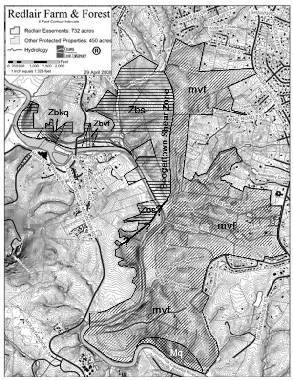
Figure 1. Geologic map of the Redlair property, Gastonia, North Carolina. Portion of Boogertown Shear Zone that is dashed with question marks is an approximate location.
Reference
Goldsmith, R., Milton, D.J., and Horton, Jr., J.W., 1988. Geologic Map of the Charlotte 1° x 2° Quadrangle, North Carolina and South Carolina (Map I-1251-E). United States Geological Survey, Miscellaneous Investigations Series.